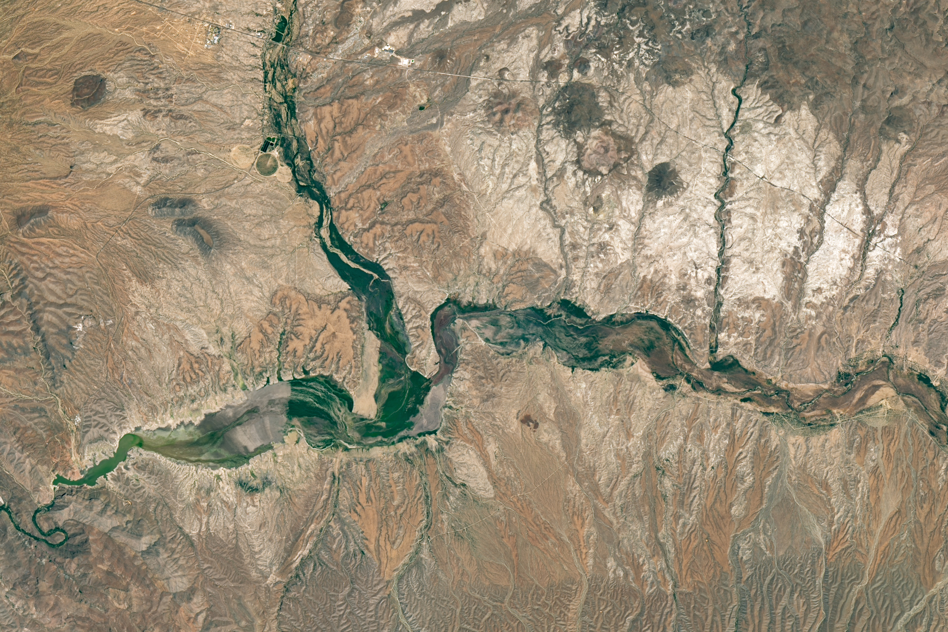
Satellite photos show beleaguered Arizona reservoir turn green
The San Carlos Reservoir, one of Arizona’s largest and most beleaguered bodies of water, has reached extremely low levels yet again, recent photos taken by NASA satellites show.
Read more 4 golden mussels found on a boat bound for Tahoe. It could have been a disaster.
The two before-and-after photos of the reservoir, which were included in a June 17 article from the agency, show starkly different images captured in 2023 and 2026. In the image on the left, which was taken in June 2023, the reservoir was a deep blue and filled to about 60% capacity. But in the image on the right, which was taken in May of this year, the reservoir was a sickly green-brown color and “near-empty” at less than 1% capacity.
In 2026, a combination of low snowpack and water released for agriculture left the lake with less than 400 acre-feet of water — and a dead fish population. “Recent drought conditions, combined with water releases from the dam, have resulted in a major fish kill affecting approximately 100% of the fish population within the lake,” officials announced this month. Following this “major” die-off, authorities indefinitely shut down the San Carlos Lake in June, citing the dangers of coming in contact with decomposed fish.
However, this is far from the only time that the reservoir has dealt with dwindling water levels and mass die-offs.
As of 2021, it has reached near-empty levels at least 20 times and has only been full three times since it was built in 1928, KJZZ reported. In the 1970s, around 5 million fish died, and it took about five years for the ecosystem to rebound, the Gila Herald reported.
Read more Ray dominant in relief as Giants complete 7-2 win over Braves in Game 1 of doubleheader

The Bay Area’s best free newsletter.
By signing up, you agree to our Terms Of Use and acknowledge that your information will be used as described in our Privacy Policy.
When it’s full, though, the lake is a major boon to surrounding communities.
Described as a fisherman’s paradise by the San Carlos Apache Tribe, the lake is lined with over 150 miles of shoreline and contains nearly 20,000 acre-feet of water when full. Considered one of the most significant tributaries in the Southwest, the Gila River, which feeds into the lake, provides water for residents, farms and wildlife.
Change could also soon be on the horizon: said that there’s a 33% to 50% chance that nearly all of Arizona will receive above-normal levels of precipitation in 2026, potentially bringing some relief to the drought-stricken region.
— California lands five universities in world’s top 25
— 2 Bay Area students die after getting trapped on Santa Cruz beach
— California man identified as Lake Tahoe drowning victim
— Calif. county dubs June ‘Traditional’ family month
Read more ‘Rogue employee’ accused of hiding uranium sample at infamous SF site
Sign up for daily SFGATE breaking news alerts here.