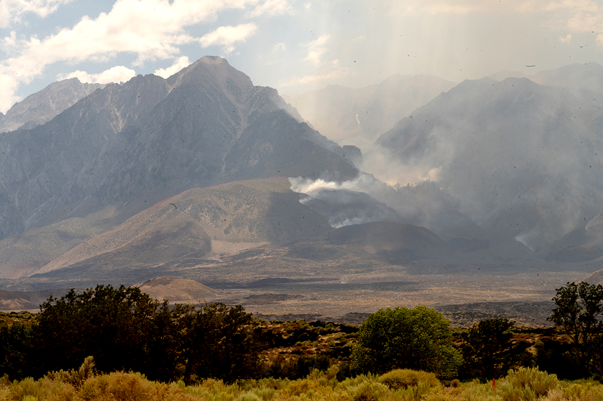
Rock Fire races into the High Sierra, burns in the John Muir Wilderness
The Rock Fire in the Eastern Sierra has advanced into the John Muir Wilderness, officials told SFGATE by phone Thursday. The fire started on Monday between Big Pine and Independence, near Highway 395, and raced across the Owens Valley, burning through terrain thick with sagebrush and volcanic rock. It is now pushing higher into the mountains and up the Eastern Sierra escarpment.
Read more Proposed Calif. law prioritizes human customer service agents over AI

In the John Muir Wilderness, flames are scaling a steep drainage that flanks Goodale Creek to reach elevations higher than 8,000 feet. The fire is burning through rugged terrain east of the Sierra Nevada crest, Kings Canyon National Park and the Pacific Crest Trail.
This terrain is “super hilly, super steep,” Ben Cossel, a Forest Service spokesperson, told SFGATE on Thursday morning. The U.S. Forest Service and Cal Fire are leading fire suppression efforts on the Rock Fire through a unified incident command. The Bureau of Land Management is also working on the fire.
It’s not uncommon for fires to burn in this area, Cossel said. Even so, the terrain is extremely challenging, which is why officials are leaning heavily on aerial resources to stop the flames.
The Rock Fire has burned 11,645 acres, as of Thursday morning, according to incident command. It is 18% contained, with containment lines abutting Highway 395, on the fire’s eastern edge. It’s continuing to advance on its western flank, moving into the High Sierra.
As of Thursday, 986 personnel were assigned to the fire, along with 29 helicopters, 110 engines, 4 dozers and 2 water tenders, according to Cossel. Night-flying helicopters made rounds across the fire on Wednesday night and air tankers will continue to make retardant drops “where necessary” throughout the day on Thursday, according to a Forest Service update.
The wilderness area also complicates fire suppression efforts.
The John Muir Wilderness encompasses 650,000 acres that stretch along 100 miles of the Sierra Nevada crest. Congress designated this swath of land as a wilderness in 1964 and named it after pioneering environmentalist John Muir. Wilderness areas strictly prohibit the use of any mechanized equipment under normal circumstances; however, federal fire policy allows the Forest Service to suppress wildfires that are burning inside wilderness areas — “with careful assessment,” said Adrienne Freeman, Forest Service public affairs officer for the Pacific Southwest region, in a phone call Thursday.
Helicopters and retardant are being used to suppress the fire in the John Muir Wilderness, Freeman said.
“We are flying helicopters with retardant in the wilderness and this is part of a full suppression strategy,” Freeman said. “When we consider these decisions we carefully weigh the ecological effect of that retardant, looking at community defense and are values at risk.”
As the Rock Fire advances into the John Muir Wilderness, it “still has a ways to go” before it reaches Kings Canyon National Park, Cossel said. The wilderness area stands between the flames and the national park.
There are no evacuations affecting Sequoia and Kings Canyon National Parks, said Holly Streit, spokesperson for Sequoia and Kings Canyon, in an email to SFGATE.
“The Rock Fire is not expected to cross the Sierra Crest into park boundaries,” Streit wrote. “Park fire managers are in regular contact with the Rock Fire Unified Command and continue to monitor fire activity.”
The fire is burning about 3 miles away from the Pacific Crest Trail, said Chris Rylee, director of communications for the Pacific Crest Trail Association, in an email to SFGATE. The Pacific Crest Trail runs through the heart of the John Muir Wilderness.
Read more Invasive ‘yellow fever’ mosquito newly found in Castro Valley
The Inyo National Forest announced a forest closure for the area in the vicinity of the Rock Fire, which went into effect on Thursday and includes four trailheads that thru-hikers often use to come off the Pacific Crest Trail and reach the Owens Valley: Sawmill Pass Trail, Red Lake Trail, Taboose Pass Trail and Birch Lake Trail.
Officials are trying to reach thru-hikers to warn them about the Rock Fire and get them off the trail to bypass the fire by using Highway 395, Cossel said.
“We are trying to get them out of the fire area,” he said. “They can’t go in. They’ve got to go around.”
Earlier this week, the Inyo County Sheriff’s Office evacuated campgrounds and rural communities near the Rock Fire. Evacuation orders remain in place, Cossel said.
The fire has continued to grow significantly since it started on Monday afternoon alongside U.S. Highway 395. Erratic winds and thunderstorms from a monsoonal weather pattern have pushed the fire from the highway, across a hilly landscape full of sagebrush, rabbit brush and salt grass, and into steep drainages that ladder up to the High Sierra.
Temperatures are heating up on Thursday, with highs expected to exceed 100 degrees and low relative humidity.
“While widespread strong winds are not anticipated, terrain-driven upslope and downslope winds, along with localized gusts from any nearby thunderstorm development, could produce sudden changes in fire behavior,” the Forest Service wrote in its Thursday update.
More concerning are the nights, Cossel said. Firefighters hope to see temperatures drop at night, with humidity in the air, to give them a window to attack the fire. But that hasn’t been happening. Instead, temperatures are staying warm overnight and the air is dry.

BECOME A FRIEND. GET OUR AD-FREE APP.
“Increased temperatures are always a concern. That is what starts getting us red flags and we start seeing that more extreme fire behavior. But combine that with the lack of really good overnight recoveries and that’s where you start having complications, really big fire days,” Cossel said. “We are right on the edge of acceptable overnight recoveries.”
Fire crews are doing everything they can to build containment around the fire, Cossel said: “The guys are doing a really kick-ass job up here.”
This story has been updated.
— Calif. traveling nurse, 27, murdered while in Michigan
— Long-awaited Highway 1 reopening has spelled disaster in Big Sur
— Woman killed herself to fulfill ChatGPT prophecy, lawsuit alleges
— Teen among dead in devastating Calif. car crash finally identified
Read more More than 30 road closures scheduled for SF Marathon
Sign up for SFGATE’s breaking news email